About Optelos

Many organizations are attempting to digitally transform their asset inspection programs due to the many cost, safety and efficiency benefits the digitization process conveys, but the amount of data involved and its unstructured nature quickly becomes a challenge. Enterprises can be left with terabytes of information stored inconsistently in multiple locations, making the data difficult to use and share. Enterprises that don’t realize the actionable insights they need from their drone-based asset inspection programs may be left behind by savvy competitors. Optelos is a flexible, scalable and secure cloud-based visual data management and AI analytics platform that transforms geovisual data into actionable insights. The patented technology geolocates and correlates all types of asset inspection data, organizing vast amounts of unstructured image and other data captured from drones, robots, CCTV’s, LiDAR, thermal and other sensor data into an intuitive, contextualized and searchable database ready for analysis and AI implementation. Leveraging computer vision AI, advanced image modeling and APIs for enterprise systems integration, Optelos enables businesses to operationalize and automate their visual asset inspection programs. Optelos includes all the tools needed to develop, test and deploy computer vision AI to automate any inspection process, then direct required asset repair actions to the precise geolocation of the detected fault. Optelos compresses the time it takes to accurately perform asset inspections by applying computer vision AI, which automates issue identification, classification, prioritization and geolocation to speed repairs of detected faults and enable better leverage scarce monitoring and repair resources. Optelos also includes features which can be leveraged to improve the effectiveness and efficiency of shutdowns, turnarounds and outages (STOs). Turnaround Advisor functionality allows maintenance teams to select specific areas in an industrial site or parts of a larger system for closer inspection and viewing without visual impairment from nearby physical obstructions. Rotate, dissect and visually inspect down to pixel-level detail items selected for maintenance action, ensuring you have a complete and detailed view of equipment in preparation for maintenance actions. Easily share these detailed digital twins with colleagues and repair partners around the world without need for access to underlying software licenses. Store all project inspection images in a visually intuitive manner, and append your 3D pointcloud models with relevant documents such as recent inspection reports, regulatory requirements, project plans or equipment start-up procedures. Sharing detailed inspection information and visual equipment status data has never been easier or more intuitive. With Optelos, enterprise users can: Aggregate and Organize Visual Data - Patented technology geolocates and correlates data from any source, organizing vast amounts of unstructured data into an intuitive, contextualized and searchable database ready for analysis and AI implementation. Immersive Data Visualizations - Utilize the Optelos platform to create precise 2D orthomosaic maps and 3D mesh and pointcloud reality models; view and share all types of data through the platform with a robust set of visualization tools and viewers. Analyze And Measure - Make precise measurements and detailed analyses of assets, structures, building sites and equipment using 3D pointcloud models. Identify and monitor a variety of asset conditions up to millimeter level accuracy. Computer Vision AI - Integrated and open AI solution offers the ability to manage the entire AI workflow within the platform. Intuitive dashboards, filters, and annotation tools to pin-point issues. Integrate to ticketing systems to drive automated actions. Tools For Managing Turnarounds - Optelos is an optimal tool for pre-planning and managing maintenance STO and TAR actions.
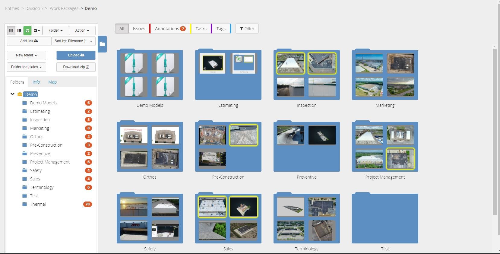
Optelos Software - Aggregate and Organize Visual Data - Patented technology geolocates and correlates data from any source, organizing vast amounts of unstructured data into an intuitive, contextualized and searchable database ready for analysis and AI implementation.
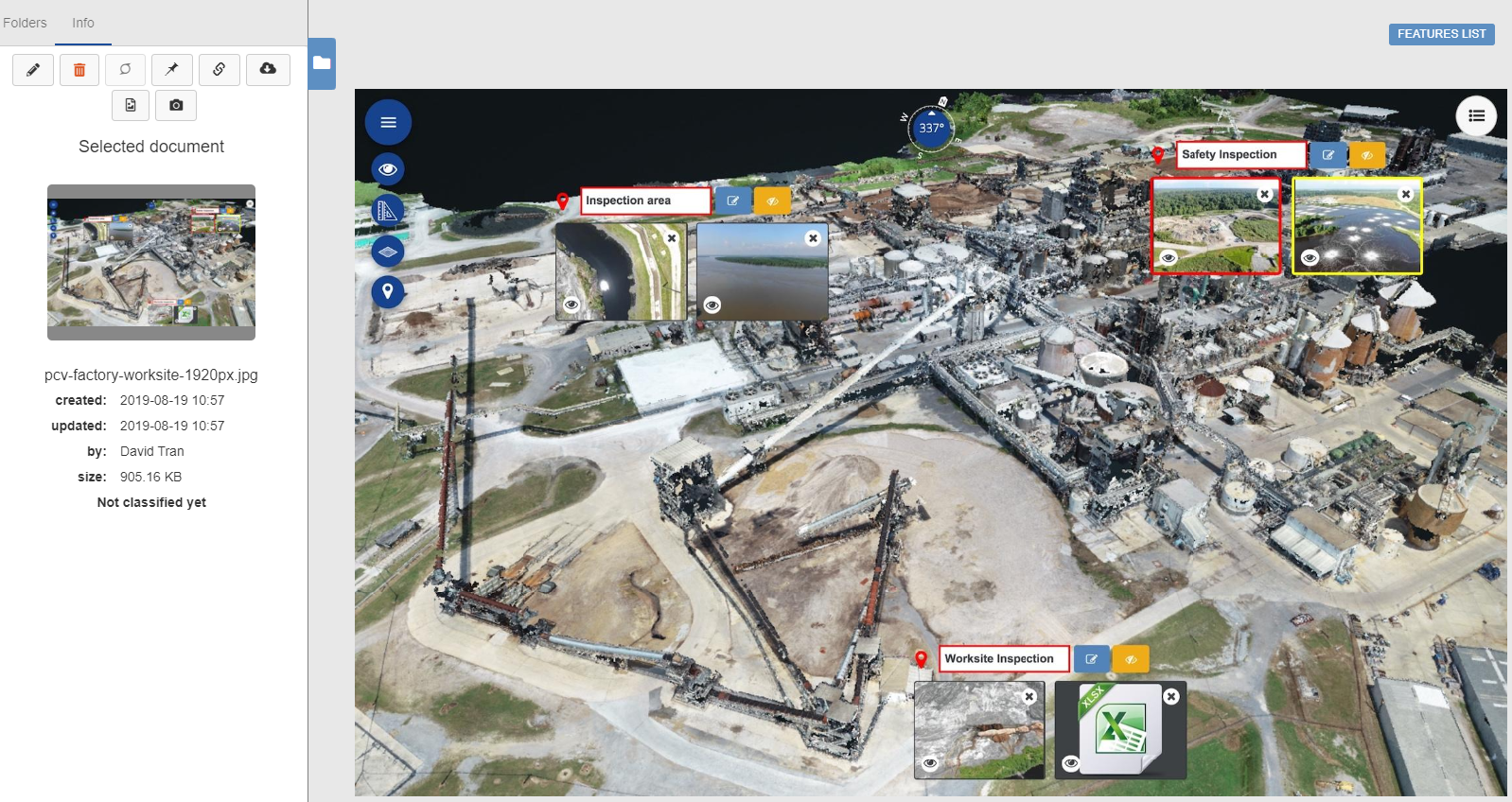
Optelos Software - Immersive Data Visualizations - Utilize the platform to create precise 2D orthomosaic maps and 3D mesh and pointcloud reality models; view and share all types of data through the platform with a robust set of visualization tools and viewers.
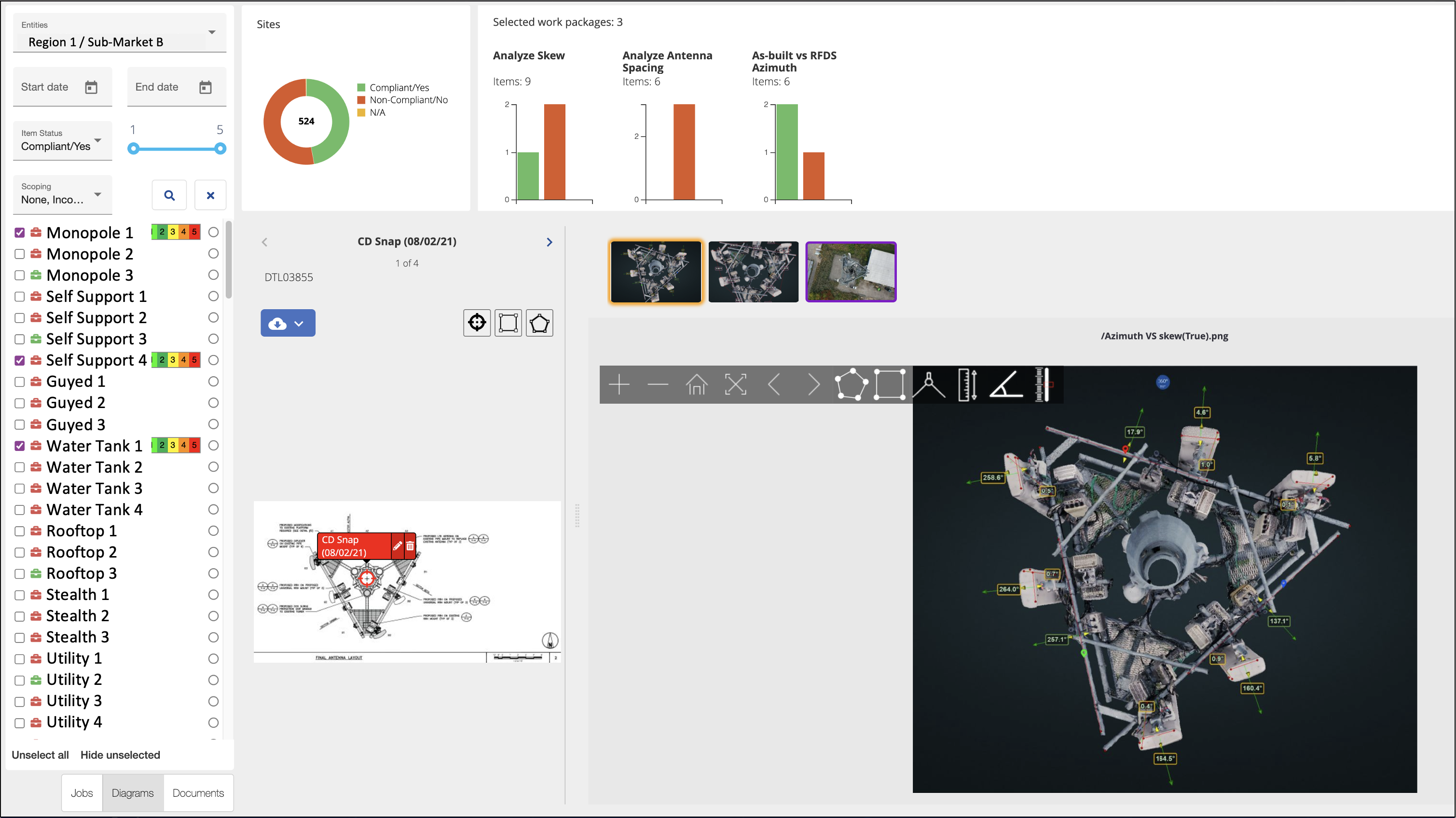
Optelos Software - Analyze And Measure - Make precise measurements and detailed analyses of assets, structures, building sites and equipment using 3D Point cloud models. Measure distances, angles, estimate volumes, azimuths and heights of objects.
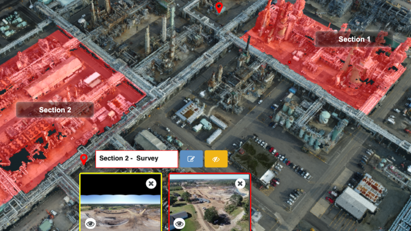
Optelos Software - Tools For Managing Turnarounds - Optelos is an optimal tool for pre-planning and managing maintenance STO actions. Group areas and equipment by STO activity, phase or team, and append relevant documents and schedule information to digital twin models.
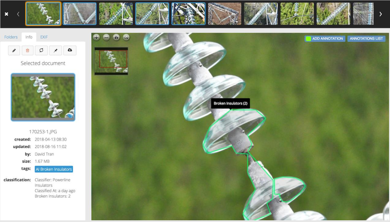
Optelos Software - Computer Vision AI - Integrated and open AI solution offers the ability to manage the entire AI workflow within the platform. Rapidly identify issues down to the pixel level. Integrate to ticketing systems to drive automated actions.
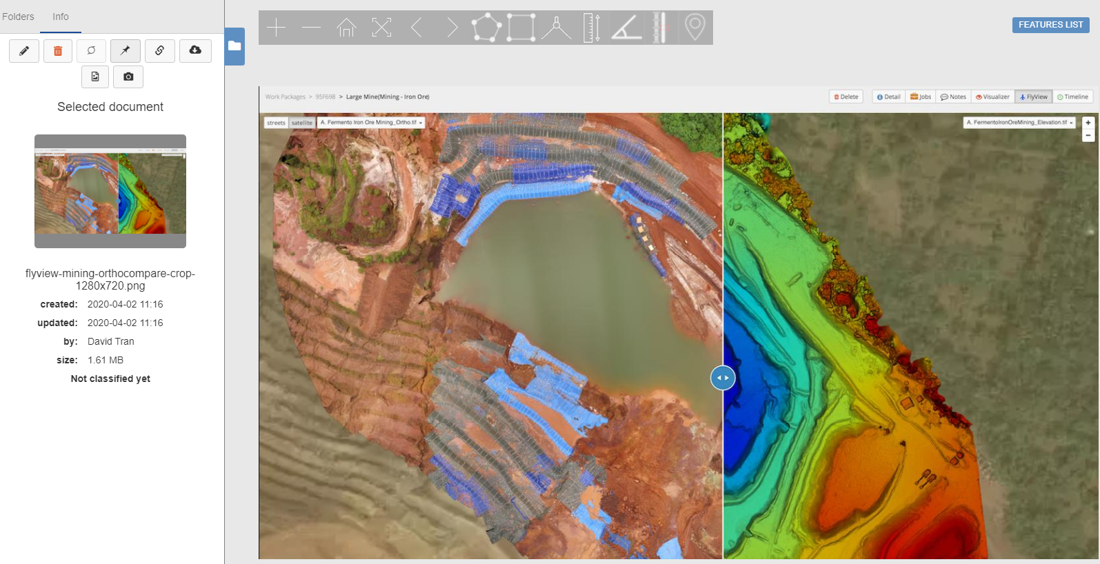
Optelos Software - Track Changes Over Time - Visualize and compare Orthomosaic maps and overlay detail maps.  Powerful OrthoCompare feature allows you to compare Orthomosaic maps to detect changes over time and perform audits. Overlay maps to visualize site progress.
Optelos video
Optelos Software - Aggregate and Organize Visual Data - Patented technology geolocates and correlates data from any source, organizing vast amounts of unstructured data into an intuitive, contextualized and searchable database ready for analysis and AI implementation. - thumbnail
Optelos Software - Immersive Data Visualizations - Utilize the platform to create precise 2D orthomosaic maps and 3D mesh and pointcloud reality models; view and share all types of data through the platform with a robust set of visualization tools and viewers. - thumbnail
Optelos Software - Analyze And Measure - Make precise measurements and detailed analyses of assets, structures, building sites and equipment using 3D Point cloud models. Measure distances, angles, estimate volumes, azimuths and heights of objects. - thumbnail
Optelos Software - Tools For Managing Turnarounds - Optelos is an optimal tool for pre-planning and managing maintenance STO actions. Group areas and equipment by STO activity, phase or team, and append relevant documents and schedule information to digital twin models. - thumbnail
Optelos Software - Computer Vision AI - Integrated and open AI solution offers the ability to manage the entire AI workflow within the platform. Rapidly identify issues down to the pixel level. Integrate to ticketing systems to drive automated actions. - thumbnail

Optelos pricing

Optelos does not have a free version but does offer a free trial.

Starting Price:
Not provided by vendor
Free Version:
No
Free trial:
Yes

Alternatives to Optelos

CounterfeitAI

0
CounterfeitAI is an intelligent, automated X-ray-based counterfeit detection system that integrates Artificial...

Lykdat

0
Lykdat is a software intended for use in the ecommerce fashion industry. It provides a personalized shopping experience...

HyperSense AI

0
Hypersense AI Studio is a no-code AI platform that can build and deploy machine learning models in minutes. HyperSense...

Optelos Reviews

Feature rating

Value for Money
4.7
Functionality
4.6
Ease of Use
4.4
Customer Support
4.8
5 reviews of 12 View all reviews
Kerrick
Kerrick
  • Industry: Construction
  • Company size: 11–50 Employees
  • Used Daily for 1+ year
  • Review Source
Value for Money
5
Functionality
4
Ease of Use
4
Customer Support
5

5
Reviewed on 26/04/2022

Photogrammetry and Construction

With file sizes getting larger and larger, you need software to view and utilize the data. Not everyone has workstations, and it is not feasible to expect the end-user to purchase something for short use. With Optelos, we are sharing data with end-users and giving them a system to utilize the information without needing their own special GIS/CAD software to use the information.

Sharing full-resolution models, point clouds, orthos, PDF, CAD, Word, or any information with our clients through a single system enables a more collaborative working relationship.

Pros

One of the best things is the flexibility to use the best tool for the given scenario. Sometimes photogrammetry isn't feasible, but Optelos offers location intelligence systems that cover all bases by pulling metadata from photos and files—allowing you to use visual data to complete your work as necessary.

Cons

The most significant limitations come from using the models for measuring and annotations. The point cloud is the primary tool you utilize to measure and annotate, and while it is more accurate. There is a time and place that I would prefer the model.

Response from Optelos

Thank you for your positive review of the Optelos software and your feedback regarding its scope, flexibility and accuracy. We certainly understand your desire to complete measurements on mesh models ("models") in addition to pointcloud models, as mesh models often appear more photorealistic and offer additional visual detail (although Optelos creates pointcloud models that can rival mesh models). As you surmised, the Optelos platform restricts measurements to pointcloud models due to their inherent accuracy. Pointcloud models consist of millions of mutually-referenced data points that offer up to 1 mm accuracy, which mesh models cannot provide to any degree.

Replied 14/06/2022
Ryan
  • Industry: Construction
  • Company size: 51–200 Employees
  • Used Daily for 2+ years
  • Review Source
Value for Money
5
Functionality
5
Ease of Use
5
Customer Support
5

5
Reviewed on 16/06/2022

The Next Generation in Roofing Companies

We have become more efficient with our estimating and project managment with optelos. Faster and more accurate estimates. Better prep with the operations team. Less mistakes in estimating and in the field. As we continue through projects the data keeps building on itself. It's so cool to look back at everything come the end of a project to see exactly how we progressed. If we did make a mistake, it's easily indentified and corrected as the software ensures the whole team is on the same page.

Pros

We had been experimenting with 3D modeling of buildings and drone software for a while and had a problem...How does one share files that are upwards of 50GB and they are not in a file format that most people can run on their average computers. In comes Optelos! This cloud based software provides a seamless environment for us to share our visual data internally and externally. The location intelligence makes going through hundreds of pictures from jobsites a thing of the past. We know where we want to look and Optelos presents everything based on GPS coordinates....even pictures from your iPhone!

Cons

Due to the software being so robust, it looks a little overwhelming at first sight. No worries though. It only takes about an hour or so to master the basic navigation of the software. Also, one must realize they are likely not going to use every feature in their business model.

Becca
  • Industry: Airlines/Aviation
  • Company size: 11–50 Employees
  • Used Weekly for 1-5 months
  • Review Source
Value for Money
4
Functionality
4
Ease of Use
3
Customer Support
5

4
Reviewed on 17/06/2022

SkyCam Aviation

It took a few tutorials sent by the company and IT help to answer our questions - once learned it is valuable but takes a bit of exploration to understand it.

Pros

File organization and annotations are helpful

Cons

Interface could be a bit clearer as to where tools are and ease of use.

Alex
  • Industry: Food Production
  • Company size: 10,000+ Employees
  • Used Daily for 6-12 months
  • Review Source
Value for Money
5
Functionality
5
Ease of Use
5
Customer Support
5

5
Reviewed on 17/06/2022

Structural Review Perspective

It has been great so far and we are exciting about furthering out partnership with Optelos as we continue to grow out global structural integrity program.

Pros

Overall ease of use, Quality of rendering, reporting, tagging videos

Cons

***It would be handy to provide a simple path for uploading rendered 3D images there were rendered locally that could be shared using the optelos platform. This adds flexibility on the end user for allowing different work flow availability

Danijel
  • Industry: Telecommunications
  • Company size: 1,001–5,000 Employees
  • Used Daily for 2+ years
  • Review Source
Value for Money
5
Functionality
4
Ease of Use
5
Customer Support
5

5
Reviewed on 15/06/2022

Essential tool for distributed asset management

Options provided us the tool to effectively monitor our own assets but also to serve a variety of industries with a single product. Tackling the Oil and Gas, Telecom, Power, and Renewables industry with one product is an amazing capability.

Pros

The ability to visualize, combine and annotate a variety of data sets all in one platform is essential to be able to maintain effective asset management. Easy of using digital twin as a base for the digital report is very unique to Optelos and creates a singular space that can be co-shared with finance, maintenance, operations, and many other teams.

Cons

The lack of ability to work with DTM and DSM models.
Related categories